
Photogrammetry 3d Modelling Using Drones has reshaped how industries capture the world from above. From construction sites to farmlands, drones now create precise 3D models that once required expensive aircraft and slow manual processes. This article explains everything you need to know—from equipment to workflows—in a clear and beginner-friendly way. Whether you’re a surveyor, engineer, or hobbyist, you’ll walk away with a deeper understanding of how drone-based 3D modelling actually works.
Introduction to Photogrammetry 3d Modelling Using Drones
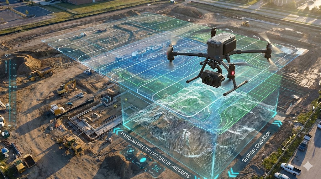
Drone photogrammetry combines aerial photography and intelligent software to create accurate 3D models of landscapes and structures. By capturing overlapping images and analyzing them through advanced algorithms, drones can generate detailed maps, point clouds, orthomosaics, and digital elevation models. Since the keyword Photogrammetry 3d Modelling Using Drones continues to grow in popularity, more industries are adopting it as a cost-effective alternative to traditional surveying.
What Is Drone-Based Photogrammetry?
Drone-based photogrammetry uses aerial images captured from a drone to calculate distances, shapes, heights, and surfaces. It relies on multiple overlapping images taken from different angles. When processed together, these images produce an accurate 3D representation of the real world.
How Drone 3D Modelling Works
At a basic level, the drone captures dozens—or hundreds—of photos. Software then identifies matching points across these photos and rebuilds a realistic model. Think of it as assembling a puzzle, except the software instantly calculates depth, texture, and elevation.
The Science Behind Drone Photogrammetry
Key Principles of Aerial Imaging
Drone photogrammetry relies heavily on image clarity and geometric accuracy. The higher the image quality, the more accurate the resulting model.
Overlap, Flight Paths & Camera Geometry
Overlapping images help ensure that the software can identify common points between photos. Standard settings include:
- 80% front overlap
- 70% side overlap
This ensures that every part of the terrain is captured multiple times.
Understanding Ground Sampling Distance (GSD)
GSD represents the actual size of one pixel on the ground. Smaller GSD values mean sharper detail. For example, a 2 cm GSD means each pixel equals a 2 cm square on the ground.
Essential Equipment for Photogrammetry 3d Modelling Using Drones
Types of Drones Used in Photogrammetry
Two main drone types dominate this field:
Multirotor vs. Fixed-Wing Aircraft
- Multirotor drones: Easy to fly, ideal for smaller projects and complex areas.
- Fixed-wing drones: Longer flight times, perfect for large-scale mapping.
Recommended Cameras & Sensors
High-resolution cameras (12 MP or more) are common. Some industries use multispectral or thermal sensors depending on the project.
Software Required for Drone 3D Modelling
Popular tools include:
- Pix4D
- Agisoft Metashape
- DroneDeploy
These programs reconstruct point clouds, orthomosaics, and textured 3D models.
Step-by-Step Workflow for Drone Photogrammetry
Pre-Flight Planning
Effective planning ensures consistent results:
- Choose optimal flight heights
- Set overlaps
- Ensure even lighting
- Check wind conditions
Image Capture Techniques
Always fly:
- At steady speeds
- With stable lighting
- At the same altitude
Data Processing & Model Reconstruction
After capturing images, upload them into your photogrammetry software.
Generating Orthomosaics
These are flat, distortion-free maps created by stitching overlapping images.
Generating DEMs and Point Clouds
Digital elevation models and point clouds reveal elevation changes and surface shape.
Applications of Drone-Based 3D Modelling
Construction & Infrastructure Monitoring
Contractors use drone mapping for:
- Progress tracking
- Volume calculation
- Terrain analysis
Agriculture & Environmental Surveying
Drones help farmers:
- Estimate crop health
- Monitor soil condition
- Map large farmland areas
Mining, Quarries & Stockpile Measurement
Companies use drones to measure:
- Stockpile volumes
- Pit depth
- Extraction progress
Benefits of Photogrammetry 3d Modelling Using Drones
Speed, Accuracy & Cost Efficiency
Drones cover large areas in minutes, capturing precise data at a fraction of traditional surveying costs.
Safety Improvements & Remote Access
Drones reach dangerous or unreachable locations without putting humans at risk.
Common Challenges & How to Overcome Them
Weather Issues
Rain, fog, or strong wind can distort images. Always check the weather beforehand.
GPS Accuracy Limitations
Using RTK or PPK drones can enhance GPS accuracy significantly.
Data Quality & Noise
Lower-quality cameras produce noisy point clouds. Use stable, high-resolution cameras for the best results.
Choosing the Best Drone for Photogrammetry
Factors to Consider
- Flight time
- Camera resolution
- GPS accuracy
- Payload capacity
Top Drone Models (Pros & Cons)
Examples include DJI Phantom 4 RTK, DJI Mavic 3 Enterprise, and WingtraOne. Each excels in different project types.
Best Practices for High-Quality Drone 3D Models
Optimal Flight Settings
Fly at consistent heights and maintain strong GPS signal.
Lighting & Timing Considerations
Midday flights reduce shadows, giving cleaner image results.
Advanced Techniques in Drone Photogrammetry
LiDAR vs Photogrammetry
LiDAR is better for dense forests, while photogrammetry offers superior visual detail.
Hybrid Mapping Techniques
Many professionals combine LiDAR and photogrammetry for ultra-precise modelling.
Future Trends in Drone-Based 3D Modelling
AI-Powered Reconstruction
AI improves accuracy and reduces processing time.
Autonomous Flight & Precision Mapping
Drones will soon perform fully automated mapping with minimal human input.
FAQs About Photogrammetry 3d Modelling Using Drones
1. Is drone photogrammetry accurate?
Yes — with proper settings, it can reach centimeter-level accuracy.
2. How long does processing a 3D model take?
Depending on image count, from 20 minutes to several hours.
3. Do I need an expensive drone?
No. Even mid-range drones produce good results with the right settings.
4. Can drones map indoors?
Yes, but GPS limitations require specialized flight planning.
5. Which industries use drone 3D modelling the most?
Construction, mining, agriculture, environmental science, and real estate.
6. Is photogrammetry better than LiDAR?
For visual detail—yes. For penetrating vegetation—LiDAR wins.
Conclusion
Drone photogrammetry is revolutionizing the world of mapping and modelling. With its speed, precision, affordability, and adaptability, it continues to replace traditional surveying in many industries. As technology evolves, Photogrammetry 3d Modelling Using Drones will only become more powerful and accessible.
🔗 External Resource: Learn more about photogrammetry fundamentals at the official GIS resource: https://www.esri.com